Cambridge Redevelopment Authority - History and Background
At the March 22, 2011 joint meeting of the Cambridge City Council's Neighborhood & Long-Term Planning Committee and the Economic Development, Training, & Employment Committee, several very informative documents regarding the history and background of the Cambridge Redevelopment Authority (CRA) were made available and entered into the record. They are reproduced below. The first was written for another purpose by CRA Executive Director Joseph Tulimieri (publication date not provided).
APPENDIX
Background of the Kendall Square Urban Renewal Area
Prior to the panel's arrival in Cambridge for its on-site investigation, panel members were provided with an advance kit reviewing the issues to be addressed. The advance kit, prepared by the Redevelopment Authority, contains a great deal of background information on the City of Cambridge. That portion dealing with project history is reproduced below.
In 1964, at the request of the federal government, the Cambridge Redevelopment Authority began the Kendall Square Urban Renewal Project (Mass. R-107) in Cambridge, Massachusetts, under provisions of Title I of the Housing Act of 1949, as amended, with a very tight time schedule in order to meet the urgent need for a 29-acre site within the project area for construction of a National Aeronautics and Space Administration (NASA) Electronics Research Center (ERC). The authority promptly completed its planning and obtained requisite approvals by December 1965.
The original urban renewal plan for the Kendall Square area which is bounded on the north by Binney Street, on the south by Main Street, on the east by Third Street and Kendall Square, and on the west by the Penn Central Railroad right-of-way was approved by the Cambridge city manager, the city council, the Commonwealth of Massachusetts, and the Department of Housing and Urban Development (HUD). The plan provided for development of the ERC north of Broadway and permitted a mix of high-density, tax-generating uses in the triangle south of Broadway. The original plan remains in effect legally at the present time.
Subsequent to receipt of the requisite approvals, including allocation of a federal capital grant of $15,333,000, NASA entered into a land disposition contract with the agreement to acquire the 29 acres and to build its ERC thereon. The land acquisitions that followed throughout the project resulted in displacement of many large industrial and business firms employing more than 2,750 people.
The authority subsequently conveyed approximately 14 acres, in several tracts, to NASA, for staged building development with appropriations approved for FY-65, FY-66, and FY-67. However, this was followed by 3 years when no funds were made available for the construction of the Electronics Research Center in FY-68, FY-69, and FY-70.
On December 29, 1969, by executive order and without prior notification either to the city of Cambridge or to the Cambridge Redevelopment Authority and contrary to its commitments to the community NASA announced the closing of its partly built Electronics Research Center and its intent to withdraw from the project.
The closing, bitterly protested by Cambridge as a flagrant breach of contractual obligations, necessitated a replanning and reprogramming of the entire renewal project area. While this effort got underway, NASA's interest in the site was being transferred to the Department of Transportation (DOT) for a transportation systems center, effective July 1, 1970.
The negotiations following the NASA closing served to further negate the original momentum for the renewal project, since no durable replanning or binding development agreements on any undeveloped portion of the project area could take place without first obtaining the necessary governmental approvals respecting the so-called "NASA surplus land."
On November 23, 1971, then Secretary of Transportation, John A. Volpe, acceded to requests from the city of Cambridge and redevelopment authority officials that his department, which had acquired the NASA buildings on some 14 acres east of former Sixth Street, relinquish any rights it had to the acreage west of former Sixth Street, under the terms of the land disposition contract, and not yet conveyed by the redevelopment authority to the federal government. Secretary Volpe also expressed agreement with the idea of a mutual exchange of certain minor land areas if it could be worked out legally.
From that date, until well into 1976, frequent meetings and exchanges of correspondence took place among the authority, DOT, General Services Administration (GSA), and HUD concerning the completion of development, the exchange of land, and the required GSA appraisals.
Secretary Volpe's statements made in November 1971, nearly 2 years after NASA's abrupt abandonment of the Kendall Square urban renewal area, were regarded as a green light for the redevelopment authority to complete its reprogramming effort involving an adjacent 13-acre triangle and the 11 acres of acquired and cleared "NASA surplus land," pending completion of federal agency negotiations.
To compound the delays respecting final agreement on the "NASA surplus land" rights, the HUD funding pipeline abruptly narrowed beginning in 1969, producing at best only small increments on a yearly basis, thus lengthening the estimated times for completion of project activities, and forcing the city to commit even greater assistance requirements which the authority obviously needed to replan and dispose of the rest of the project.
In recognition of the lack of sufficient federal grants for completion of project activities, the U.S. House Subcommittee on Housing and the full Committee on Banking and Currency in 1972 included in their "omnibus housing bill" (H.R. 16704), a provision which would have authorized the HUD Secretary to approve an application for an amendment to the urban renewal contract for the Kendall Square project to provide all funds necessary to complete the project. The omnibus legislation failed to clear the House Rules Committee, however. Efforts by the city of Cambridge to secure legislative and/or administrative remedies continued.
In January 1972, the authority issued a preliminary reprogrammed concept plan for the project area for local review and comment. Under this proposal, the triangle parcel would be developed intensively, for mixed office, commercial, residential, and hotel uses, while the "surplus land," or quadrangle parcel, would be developed predominantly for market-rate, high-rise residential uses. Substantial local opposition to this plan, particularly with respect to the quadrangle provisions, caused the authority to reconsider the proposal.
In July 1973, the Cambridge city council passed an order directing the authority to institute a development plan that would create and provide maximum blue collar and nonprofessional white collar jobs for Cambridge residents. The council also directed that a Citizens' Task Force be formed to advise the authority with respect to this revised development plan.
As a result of this process, three alternative development plans were considered by city council: a task force plan, a neighborhood (MIT) plan, and a city manager's plan. On October 9, 1974, the city council voted 5 to 4 to accept the neighborhood plan, in principle, as a minimum for development in Kendall Square. The council also directed that the city manager's and task force plans be submitted as alternatives for the purposes of the forthcoming environmental impact study.
While local development objectives were being agreed upon, progress was being made in securing federal project completion commitments. HUD Secretary James T. Lynn in 1974 agreed to "reserve" $15 million plus interest in additional capital grant funds for the project. The authority's formal application for the "reserved" funds was submitted in September 1974, and is still under review in the Boston area office of HUD. Whether this will, in fact, represent "all funds necessary to complete the project" cannot be determined at this time. HUD's superimposed requirement, for example, that the change in land use for the quadrangle constitutes a major plan change and that therefore an environmental impact statement must be prepared before commencement of additional development may subject project costs to further inflationary forces as more time elapses.
As further remedial action, late in 1975, Congress passed and President Ford signed legislation limiting the city of Cambridge's share of the project cost to the initial $6,416,500 contributed in 1965, primarily by MIT in the form of Section 112 credits. These credits are made up of the cost of certain real estate acquired for educationally related purposes by the donor institution.
The next document was written specifically for the March 22, 2011 committee meeting by Robert Simha. It has been only lightly edited for punctuation, spelling, etc.
The Cambridge Redevelopment Authority
This brief summary of the history of the activities and operations of the Cambridge Redevelopment Authority was prepared at the request of Councillors Cheung and Seidel of the Cambridge City Council to assist them in their review of the CRA scheduled for March 22, 2011.
Some Historical Milestones
The Federal Housing Act of 1949 as amended in 1954 and 1955 established under Title I of the Act a "Slum Clearance and Urban Renewal Program". To participate in this program, cities were required to develop a "Workable Program" ... "which shall include an official plan of action, as it exists from time to time, for effectively dealing with the problem of urban slums and blight within the community and for the establishment and preservation of a well planned community with well organized residential neighborhoods of decent homes and suitable living environment for adequate family life. Section 101 Local Responsibilities paragraph (c)"
The City of Cambridge initially took advantage of the provisions of the act by authorizing the Cambridge Planning Board and its staff to develop an inventory of possible areas that would meet the criteria for the uses of urban renewal funds. All, within the context of a comprehensive City Plan. This planning work was initially conducted by the staff of the Cambridge Planning Board in 1957-58 under Mr. Mark Fortune, then Planning Director for the Board. His successor Alan McClennen at the Planning Board continued to provide planning assistance to fulfill the planning requirements of the Urban Renewal Program. It should be noted that the planning staff at the time was quite small. Perhaps under 5 employees.
The City Council established in 1954 a Citizen's Advisory Committee (the CAC), as required by the Housing Act, which included citizens from all sectors of the community including the presidents of both major universities in Cambridge. The purpose of the CAC was to identify major economic, physical and social planning issues that the City should address as it planned for its future.
In 1955 the redevelopment and renewal functions were transferred to a newly created Cambridge Redevelopment Authority. The first chairman of the new authority was Mr. Paul Corcoran, then President of Corcoran's department store in Central and Harvard Squares. The Cambridge Redevelopment Authority had a small staff who engaged consultants to identify the specific needs of areas of the city that had been identified by the Planning Board as appropriate targets for the Urban renewal program.
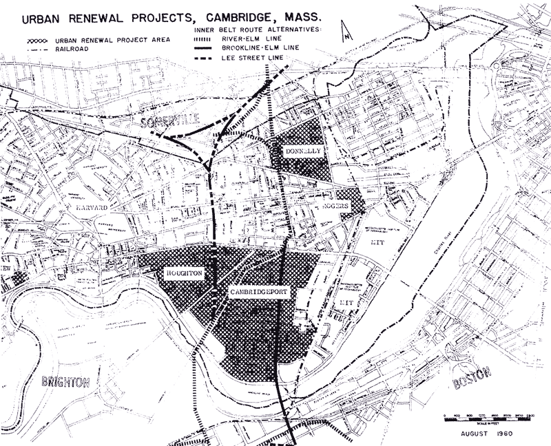
Five areas were identified. These included:
The Riverview Site at 221 Mt. Auburn Street and Bradbury Court
The Rogers Block site on Main Street
The Cambridgeport Neighborhood
The Riverside Neighborhood
The Donnelly Field Neighborhood
* see attached map
Of these areas the City Council authorized the Redevelopment Authority to pursue the redevelopment of the "Riverview site" at 221 Mt. Auburn Street for the development of new housing units. The existing wooden houses on the site were acquired and the site cleared and sold to M. Kargman, a real estate developer who built an apartment house and a group of town houses with a total of 80 units in 1963. Originally built as rental housing, the project was ultimately converted to condominium ownership.
The second project was the so called Rogers Block, a 4.5 acre block occupied by a large wooden tenement building owned by the Rogers Family Trust, located on Main Street just west of the RR tracks, which was largely vacant. On November 22, 1957 the buildings were acquired and demolished and the Redevelopment Authority placed the property on the market. The site was adjacent to the large Lever Brothers soap plant which occupied about 11 acres of adjacent land that stretched from Main Street to Broadway and from the Grand Junction railroad track to Portland Street (now Cardinal Medeiros Blvd.). The only interest expressed in the Rogers Block site was from a mattress company. The Redevelopment Authority did not believe this was a use that had long term value and so the site remained vacant for close to two years. However, in 1959, the Lever Brothers Company, that had moved its national headquarters at 50 Memorial Drive to New York in 1951, announced that the soap plant would be closed and the property placed on the market. It was at that point that MIT in partnership with Cabot Cabot and Forbes stepped forward to propose the development of Technology Square which would include, if the city wished, the Rogers Block area. The City agreed to the sale of the Rogers Block land to the new Technology Square entity and the area was included in the overall Technology Square development. On January 11, 1960 demolition of the former Lever Brothers soap plant began and the site was cleared for development. The first building was completed and available for rent in 1962-3 and other buildings were added, largely for the Polaroid Company, in the following years. By 1975, half of the project's full development potential was in place.
The other three areas, Riverside, Cambridgeport and Donnelly Field were all subject to the impact of one or another route of a proposed inner belt, interstate highway. The Redevelopment Authority had requested a preliminary commitment of eleven million dollars in funds from the Urban Renewal Administration to conduct planning studies to deal with the impact of the highway, should it be built. A reservation of these funds was made on behalf of Cambridge by the Urban Renewal Administration. The long delays in the decision to locate the highway and ultimately the decision not to build the highway resulted in the federal government rescinding the reservation of eleven million dollars in funds which had been reserved for planning these areas.
In late 1964 and early 1965, as the Technology Square project moved forward with the construction of several new office buildings, the National Aeronautics and Space Administration (NASA) began seeking a site in Cambridge to house its electronics research center. A group of three planners employed by the Boston Redevelopment Authority, led by Mr. Robert F. Rowland approached the Cambridge Citizens Advisory Committee with a proposal that Cambridge acquire the necessary land in and around Kendall Square to accommodate the NASA center. They also recommended that the 13 acre triangle site between Main Street, Broadway and the Grand Junction Railroad be acquired to create new tax paying commercial, residential and retail development to help offset the loss of taxes from land assigned to the Federal government. A key element of their proposal was that the cost of the City's share of this development could be paid for by contributions MIT would make under Section 112 of the Housing Act. That section of the law provided that any expenses MIT incurred to acquire land, and buildings for educational use within a mile of the redevelopment site could be counted as the City's share of the net cost of the project. The result would be that the City would be able to proceed with the project without expense. The Redevelopment Authority engaged Mr. Rowland to carry the project forward and establish the Kendall Square Urban Renewal Project. The City Council approved the project in the summer of 1965 and concluded its agreement with MIT to provide the financing for the project on August 30, 1965. MIT then agreed to provide $6.2 million dollars in credits to the City to finance the project. In turn, MIT was required to submit to the city a Development Plan and to receive approval of the plan from the City Council. The plan included all of the property listed under this agreement that were to be used exclusively for educational purposes.
The Redevelopment Authority under Mr. Rowland's leadership then proceeded to acquire the properties within the project boundaries and to arrange for relocation assistance for the business organizations that had formerly occupied the site.
The Redevelopment Authority staff and its consultants prepared a land use plan and circulation plan for the area and proceeded with the task of assembling land for the NASA research center. The site preparation required was extensive and involved, among other things placing the Broad Canal in an underground pipe from Third Street to the site of the then Boston Woven Hose/American Biltrite Rubber Company facilities now know as 1 Kendall Square.
In April of 1966, the CRA designated a 29 acre site for NASA's Electronic Research Center. NASA retained Architect Edward Durrell Stone to design the campus and buildings for their research center. The CRA established a Design Advisory Group (DAG) to review NASA's plan. The DAG was disappointed with Mr. Stone's initial proposals and the CRA expressed the City's reservations to NASA. NASA administrators acknowledged the CRA's concerns, but proceeded to build their buildings as designed by Mr. Stone, with only minor modifications. The CRA continued to transfer property to NASA as the land became available.
In December of 1969, President Richard Nixon decided to terminate the NASA Electronics Research Center that was to be located in Kendall Square. NASA informed the Cambridge Redevelopment Authority of the decision. This triggered an effort to find another suitable user for the space that had been reserved for NASA. Fortunately, former Massachusetts Governor John Volpe had been appointed by the Nixon administration as the Secretary of Transportation and he proposed that the land and facilities which had been earmarked for NASA should be devoted to the establishment of a Department of Transportation (DOT) Research Center. With the agreement of federal authorities and Cambridge this change was made. In January of 1971, the Federal government released 11 of the original 29 acres it had acquired as part of this agreement to Cambridge for other development.
The City Council then asked the Cambridge Planning Board to develop guidelines for the distribution of this newly available land. The Planning Board identified six options, one of which was to sell the land to MIT for academic purposes with the expectation that the Institute would pay taxes on the land. MIT demurred but proposed that a significant amount of the land should be used for the development of new housing to help make the area a more lively 24/7 neighborhood. In 1972, the CRA offered an alternative plan for intensive business development on the site. The City Council rejected this proposal in 1973. In an effort to find some consensus as to the future use of the undeveloped land within the urban renewal area, Mayor Barbara Ackermann appointed, in July of 1973, a Kendall Square Task Force made up of representatives of each city councillor, the Cambridge Civic Association, MIT and the surrounding neighborhoods of East Cambridge, Wellington-Harrington and Neighborhood 4. Mayor Ackermann appointed Mr. Brett Donham of the Civic Association the Task Force chair and the CRA provided staff support. The Task Force met for over a year and in 1974 the Kendall Square Businessmen's Association, the East Cambridge Planning Team and MIT offered a "neighborhood plan" that featured mixed uses for the site including housing, commercial development and research and development activities.
It quickly became clear that Mr. Donham and other non-neighborhood task force members such as Ms. Gladys Gifford of the Harvard Square area opposed a plan which included housing and preferred an exclusive commercial and industrial redevelopment. In spite of the fact that a majority of the businesses and residents to be impacted by the redevelopment wished for a mixed use development, Mr. Donham, through his exercise of the chair, thwarted a majority vote and the result was that no formal recommendation was made to the City Council. This left open a vacuum into which City Manager James Sullivan presented a "Manager's Plan" which allowed but did not require housing in the development. The Council approved this plan and the CRA proceeded in 1975 with the changes in the project.
As a result of the difficulties created for Cambridge by the cancellation of the NASA project by the Federal administration and through the support of Cambridge's congressional delegation the city was able to obtain an additional 15 million dollars in funding to cover the remaining local share of the project.
Continuing public hostility toward the Manager's Plan for the area led to a new effort to organize a consensus for the development of the site. The CRA sought the assistance of the business-oriented Urban Land Institute who brought in a panel of outside real estate developers who recommended a mixed development district but without a mandatory housing component. That view prevailed with members of the City Council and the necessary zoning for this plan was approved by the City Council in 1977.
In 1978, the CRA advertised for developers. Four developers submitted proposals. The lack of interest by the development community evidenced by the fact that there were only four proposals was in part a reflection of the difficult economic times of the late 1970's. Of the four proposals, three included housing and significant retail space (120,000 to 235,000 square feet) for the development. The fourth, Boston Properties, proposed no housing and a maximum of 50,000 square feet of retail and consumer services. The CRA designated Boston Properties as the developer of the 13-acre triangle parcel earmarked for new commercial development.
It became quite clear from the outset that Boston Properties, an office developer, led by Mr. Mortimore Zuckerman and Mr. Edward Lindy were intent on creating a series of office buildings lining Main Street which gave little regard to design considerations that had been set forth to reflect both the MIT campus on the south side of Main Street or the DOT center on the north side of Main Street. Complaints were lodged with Boston Properties in April of 1979 by the CRA and MIT about the architectural design of the buildings they were proposing. In view of these complaints Boston Properties made changes in their proposal by reducing building heights and they also offered to change architects. They left the NY architects who had prepared their original proposals and hired local architect Moshe Safdie and Assoc. Safdie's office designed the remainder of the buildings within the triangle area bounded by Ames Street Main Street and Broadway. [http://www.msafdie.com/#/projects (see 1988 Cambridge Center)]
In subsequent years the CRA transferred the development rights in land vacated by the Federal government to Boston Properties for further expansion of the commercial development of the area. During periods of economic downturn Boston Properties proposed to the CRA a range of alternate development projects including housing and retail activities but none of these where brought to fruition. Boston Properties also made available sites from its development inventory for the Whitehead Institute and the Broad Institute with the permission of the CRA.
After the major land assembly and transfer activities in Kendall Square were completed the CRA reduced its staff and has operated with only an executive Director and administrative staff since. There are still some small areas from the original plan that may be developable but at the behest of the CRA and the developer, Boston Properties, the Cambridge Planning board and the City Council has agreed to additional development capacity within the project area. The first was a 200,000 square foot addition that can be used only for housing and the recent award of an additional 300,000 square feet of development area to accommodate the expansion and consolidation of the Broad Institute.
The history of the agency suggests that the City has been willing to maintain, over the years, both a community planning and development agency (CDD) and an independent redevelopment agency (the CRA). Since the late 1960's the CRA has focused most of its energy on the Kendall Square Urban Renewal Area. The CDD in contrast has been involved in the development of plans and development opportunities at a number of major development sites, some of which parallel the activities of the CRA. The Lechmere Riverfront area, University Park, North Point, East Cambridge are some examples. The CDD has frequently championed housing as part of its development planning. In contrast the CRA has to a large extent focused on supporting the Boston Properties initiatives that feature commercial office and R&D space. The CRA in a major review of the zoning for East Cambridge in the late 90's did champion the redevelopment of unused land at the DOT center for housing and much needed public open space.
When the CRA was established the members of the Authority were well known and highly regarded citizens representing a cross section of the city. At present, there is no public indication of the membership of the Authority on the city's web site.
In any review of the CRA, as one of the city's major development agencies it should be noted that the agency and its Executive Director, Joseph Tulimieri, have played an important role in the renewal of the city's economy. It operates in a lean and efficient manner and it has played an important role in revitalizing the Kendall Square Association. Its future role as a planning and development organization should be carefully considered in the context of the future needs of Cambridge.
Note: At the committee meeting, CRA Executive Director Joseph Tulimieri noted that of the five members of the CRA (four appointed by the City Council and one by the Governor), two seats are currently vacant and the other three are "holdover" appointments whose terms have expired but who continue to serve according to state law. These members are Alan Bell and Mark Rogers (City Council appointees) and Jackie Sullivan (governor appointee).
Kendall Square, a brief historical sketch - by Sam Seidel (Mar 17, 2013)
Any additional background information on the Cambridge Redevelopment Authority or the history of urban renewal in Cambridge are welcome and will gladly be added to this site. Corrections are, of course, also welcome. - Robert Winters, Editor