CENTRAL SQUARE AND OSBORNE TRIANGLE PLAN & RECOMMENDATIONS
A PLACE FOR LIVING
Increase housing stock and support community diversity through more varied housing choices
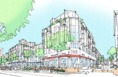
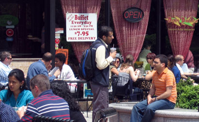
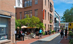
Massachusetts Ave: Housing framing a public plaza and additional retail |
CONNECTING PEOPLE TO THE SQUARE
Enrich neighborhood walkability and livability with safe, green streets and improved access choices
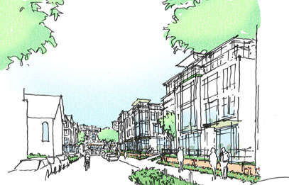
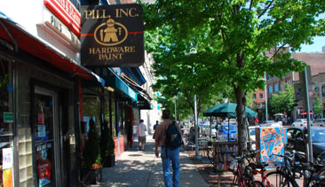
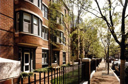
Bishop Allen Drive: Green infrastructure and neighborhood-scale housing and small business spaces enhancing walkability along |
PUBLIC PLACES TO BUILD COMMUNITY
Enrich the Square's public realm as place that invites community interaction at many levels
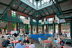
|
RETAIL, CULTURAL AND NON-PROFIT DIVERSITY
Celebrate and maintain the mix of old, new, venerable and funky enterprises activating Central Square's Cultural District
|
Central Square Advisory Committee: 2011/2012
| Patrick W. Barrett III |
|
Sean Casey LLC, Resident (Area 4) |
| Anya Alexandra Bear |
|
MIT |
| Mark Boyes-Watson |
|
Resident (Cambridgeport) |
| Kathryn Lachelt Brown |
|
Forest City |
| Kara Cournoyer |
|
Novartis |
| Susan Fleischmann |
|
CCTV, Resident (Mid-Cambridge) |
| Josh Gerber |
|
1369 Coffeehouse |
| Randa Ghattas |
|
Resident (Area 4) |
| Nicholas Haney |
|
Intercontinental Real Estate (through Oct, 2012) |
| Esther Hanig |
|
Resident (Area 4) |
| Ming-Tai Huh |
|
Resident (Area 4) |
| Gavin W. Kleespies |
|
Cambridge Historical Society, Resident (Cambridgeport) |
| Robin Lapidus |
|
Central Square Business Association |
| Morris M. Naggar |
|
3MJ Realty |
| Heather Nelson |
|
Resident (Mid-Cambridge) |
| Ahmed Nur |
|
Planning Board/Resident (Mid-Cambridge) |
| Patrick Rowe |
|
MIT |
| Loryn Sheffner |
|
Resident (Riverside) |
| Michael Simon |
|
Central Property |
| Saul Tannenbaum |
|
Resident (Cambridgeport) |
| Gail Willett |
|
Resident (Cambridgeport) |
| VISION |
OBJECTIVES |
CORE STRATEGIES |
TOOLS |
| Central Square is Cambridge's downtown and a center for nearby neighborhoods; a vibrant cultural district; a sustainable urban environment that invites people from all walks of life to shop, live, enjoy entertainment and the arts, find community together; and more. |
Articulate objectives that achieve the spirit as well as the letter of the vision. |
Take bold steps to achieve a melding of longstanding community aspirations and emerging opportunities. |
Capture increased economic value for community benefit. |
The architect Jan Gehl's assertion "First life, then spaces, then buildings: the other way around never works" captures the Square's spirit and the spirit of planning for its future…
First life… of Central Square is about welcoming the diversity of the people who use it: a spectrum of incomes; children and retirees and every age in between; people of many races and ethnicities; techies and artists; Cantabrigians and tourists; residents and workers, retailers and students; lifelong residents and newcomers; people who use the square to connect to myriad other destinations and as their "living room;" to hang out. People from every walk of life have a stake and can contribute to the Square's vitality.
Then space… is about enhancing Central Square as a downtown whose mix of uses and character invites and expresses diversity: changing character by location; home to long-term and new local businesses along with childcare centers and late night music venues; respected and beloved educational and cultural institutions; public spaces that celebrate the arts and technology; streets intended for transit, walking, biking, and festivals as well as cars; a public realm marked by green lawns, trees, and flowers and the lively sidewalks of Massachusetts Avenue; parks and squares that invite quiet conversations between friends and the buzz of everybody's downtown. This rich mix brings the Square to life.
Then buildings… express this mix with variety that reinforces both the vitality of a downtown and the livability of adjacent neighborhoods: an emphasis on housing for a diversity of people and households; a love of innovation and a commitment to preserve a rich heritage; blocks that mix taller structures with shorter ones; buildings that step down to a quiet residential face toward nearby neighborhoods and up to a vibrant mixed-use face toward Massachusetts Avenue. A constant variety in massing and design can invigorate the heart of the Square and respect its neighbors.
Celebrating this rich mix represents a unique opportunity. Nurturing it represents a responsibility shared by the entire community. |
1. PUBLIC PLACES TO BUILD COMMUNITY
Enrich the Square's public realm to invite community interaction at many levels from meeting a friend to citywide festivals.
2. RETAIL, CULTURAL AND NON-PROFIT DIVERSITY
Celebrate the mix of old and new, verable and funky, culture and business and other sources of diverse activities that make the Square a great Main Street and Cultural District.
3. RESIDENTIAL DIVERSITY
Support a diverse community through more and varied housing choices.
4. CONNECTING PEOPLE TO THE SQUARE
Enrich neighborhood walkability and livability with safe, green streets and improved access choices. |
1. Expand the supply of housing for a wide spectrum of incomes (from low to market rate) and household types ( from family to micro-units)
2. Vary the mix of uses, heights, and massing to reinforce the specific character of each part of the Square:
o Greatest variety of heights, massing and mix of uses along "downtown" Mass Ave and the Osborne Triangle except for Main Street.
o Mixed-use neighborhood character along Main Street.
o Lower heights, traditional setbacks, more residential focus in the transition areas.
3. Transform the Square's public spaces (including Mass Ave and other streets) into a connected system extending from University Park to the City Hall lawn, designed, programmed and managed to accommodate a wide spectrum of people and activites.
4. Maintain public control of public spaces.
5. Preserve and expand the variety of types and scales of retail.
6. Emphasize transit, bikes, and walkability over cars.
7. Where possible reduce parking requirements for housing, replacement parking, etc. to facilitate achieving other strategies. |
1. Reuse city-owned parking lots to expand housing supply with a focus on mixed-income housing together with new public space.
2. Leverage the value of public parking lots to maximize affordable housing, replacement parking, public space and other community benefits.
3. Use height and density bonuses for private sites to incncentivize creation of mixed-income housing, affordable retail and non-profit space, a variety of public space, and other community benefits.
4. Allow use of Transfer of Development Rights (TDRs) in return for community benefits
5. Exempt area of ground floor retail or other permanent active use from counting toward density limits in return for a variety of retail types and sizes.
6. Tailor height and density bonuses and related community benefits to meet specific goals for the Osborne Trangle, Mass Ave "downtown" and other areas.
7. Permit parklet installations in underutilized sidewalk and/or parking spaces that engage businesses and organizations in their concept, funding and management.
8. Waive upper floor façade setbacks along Mass Ave/Main St façade frontage and requiring upper floor setbacks on side streets, with streetwall heights transitioning from higher Mass Ave/Main St elevations to lower neighborhood streetwall precedents.
9. Explore a greater partnership between the City and CSBA to address the Squares human and social service needs. |
Goal 2: PUBLIC PLACES TO BUILD COMMUNITY
Leverage city owned property and new development partnerships to enrich the Square's public realm as place that promotes community interaction
| OBJECTIVE |
PROPOSED STRATEGIES (ZONING) |
PROPOSED STRATEGIES (NON-ZONING) |
| A. Establish Massachusetts Avenue & Main St as a great public place |
1. Promote lively mixed-use activity in the Central Square core along Massachusetts Avenue between City Hall and Jill Brown-Rhone Park and Main Street to connect to Kendall Square.
o In Osborne Triangle west of Windsor Street, increase activity and sense of neighborhood around Jill Brown-Rhone Park and decrease the dominance of commercial uses that are not pedestrian-oriented in the area.
o Require active ground floors (either retail or designed to accommodate retail in the future) with small allowances to accommodate lobby spaces; see Retail, Cultural and Non-Profit Diversity for more detail. |
1. Continue application of the façade, signage and lighting improvement program.
2. Encourage businesses/organizations to be stewards of adjacent public places including allowances for limited retail activity spilling out into public space
3. Link sidewalk dining with requirements for enhanced maintenance of adjacent spaces
4. As part of the City's LED conversion, give priority ot Central Square and create a plan to improve pedestrian street lighting that addresses safety, identity, and convenient access to evening cultural and dining destinations.
5. Improve pedestrian flow through Carl Barron Plaza by widening walkways, include wayfinding elements, and work with MBTA to optimize bus operations and bus stop locations near Green St/River St corner
6. Create a cohesive character along the streetusing streetscape elemtns such as bike racks, seating, trees, lighting etc.
7. Create places to gather that include seating and are appealing to everyone; focus on areas adjacent to active ground floors that provide stewardship and "eyes on the street" |
| B. Add and improve public spaces to invite a broader range of community activities |
1. Create new outdoor and/or indoor public gathering spaces through use of zoning requirements and incentives
o Incent creation and programming of new/enhanced public space types as part of major redevelopment projects:
• 1-2 additional public gathering spaces up to approx. 1,000-3,000sf in area, facing Mass Ave between Prospect and Lafayette Square, with dining and/or other active uses, preferably in sunny (north side) locations.
• Public room/public market or similar enclosed space with significant daylight, approx. 5,000sf in area for year-round activity as part of or adjacent to an outdoor gathering space
• Use City resources to maintain fully public nature of public spaces and privately owned spaces open to public use based on permit conditions or developemnt or other agreements with the City.
2. Accompany creation of any new public gathering spaces with efforts to expand the "public" using them, through associated creation of housing, as well as retail, cultural and/or office space drawing more people to Central Square daily.
3. In case of redevelopment, use special permit process to enhance existing public spaces
4. Break up large blocks in Osborne Triangle by creating pedestrian connections, covered or open, which enhance community connectivity e.g. Village St extension, which would create a connection between Mass Ave and Main St. |
1. Create a public-private program for creation of parklets on the sidewalk and/or replacing vehicle spaces in appropriate locations.
o Implement at least 1-2 "parklets" per year toward goal of 5-6 priority parklets (see public places diagram). Parklets, typically occupying an area of roughly 200 to 500 square feet, should take the place of underutilized on-street parking spaces and/or sidewalk space. Partner with adjacent business and/or property owners to obtain their assistance funding, conceiving, designing and maintaining parklets.
o Public spaces should be designed to invite community and encourage interaction
o Review City processes to eliminate barriers to 'Tactical Urbanism'
2. If City parking lots are redeveloped, a significant outdoor and/or indoor public space component should be included, as well as housing and/or retail helping activate the new public space (in event of associated redevelopment of adjacent private sites, coordinate with zoning strategies at left) |
| C. Intensify programming of public spaces within the Central Square Cultural District to provide opportunities for community activity, celebrating cultural diversity and the arts |
|
1. Enhance programming of public spaces by working with CSBA, City agencies, neighborhood and other groups to manage placement and scheduling of elements including buskers, temporary/ mobile retail, information (i.e. real-time transit & event information) and festivals.
o Designate a go-to contact person coordinating scheduling of all Central Square events in public places. Invite participation by all (community groups, cultural organizations, businesses etc.) in programming public places.
2. Work with CSBA, CAC, and property owners to expand ways to integrate more engaging, playful public art engaging people of all ages
o Examples of public art applications: in future parklets, vacant storefronts, working with the Healthy Play Initiative to explore artistic/whimsical treatments of streetscape elements such as benches, bike racks, trash cans etc. |
| D. Ensure positive relationship of new development to public space |
1. Refine development and design guidelines, with emphasis on limiting shadow impacts on neighborhoods and public spaces; ensuring transparent retail storefronts; enhancing residential street edges and accessibility; encouraging variety in architectural form and expression; ensuring new building heights and lengths to fit with context scale; and activating side streets with appropriate retail and office uses. See Residential Diversity goal for more detail.
• Impose the established Mass Ave upper floor setback policy along facades perpendicular to Mass Ave, with a base streetwall height of 55' within one-half block distance of Mass Ave and a base streetwall height of 45' (or matching adjacent zoning district condition) elsewhere.
• To promote variation in building profile and deeper upper floor setbacks on side streets, allow residential sections, with floorplates of 10,000 sq. ft. or less streetwall to be exempt from height setback requirements on the Mass Ave face of a development parcel.
• Drive the creation of community benefits like affordable housing, retail and non-profit space through incentives such as density and/or height increases where appropriate. See Zoning Recommendations for more details. |
1. If City parking lots or other public buildings are redeveloped, apply updated design and development guidelines to maximize the quality of any new public places created as well as to avoid negative impacts (i.e. shadows, loss of sky plane) on established neighborhoods. If a building is being redeveloped include creation of civic/public uses and indoor public gathering space such as a public market. |
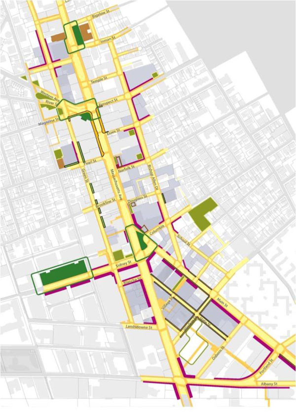
Public Places elements
Major Spaces and Squares
Qualities
• Significant size and/or activity level • Regular programming, quality facilities
Key locations and priority initiatives
• City Hall Lawn and Square: enhance programming along Post Office building per Plaza and Parklet categories below.
 • Carl Barron Plaza and Square: introduce more event programming, beginning with quickly- implemented smaller events (see Parklets, below) and building toward larger events enabled by creation of broader open spaces on the plaza.
• Jill Brown-Rhone Park and Lafayette Square: introduce more active ground floor retail and residents near the park to take advantage of expanded programming opportunity.
• University Park Commons: enhance perception of public access through such means as removing perimeter fencing, adding programming for children, and continuing to host public events; improve wayfinding and signage to connect it to Mass Ave.
Parks and Plazas
Qualities
• Intermediate size and/or activity level
• Programming responds to more specific set of users
• Complement adjacent City facilities such as public room/market
Key locations
• Create one or more pocket parks along Bishop Allen Drive through conversion of current city parking lots. Alternative program concepts for further exploration may include a pedestrian court connecting Bishop Allen and Massachusetts Avenue, passive lawn space, and/or childrens' play space.
 • Enhance the plaza in front of the Post Office as a usable and identifiable space
• Create one to two small plazas (approximately 1,000-3,000sf) along the north side of Massachusetts Avenue in conjunction with redevelopment projects over 50,000 sf. Emphasize opportunities for outdoor dining and seating, taking advantage of good access to direct sun.
• Proceed with planned improvements to Western Avenue/River Street park spaces, for coherence and usability.
 • A near-term small plaza at Bishop Allen and Main, and a publicly accessible courtyard at the Novartis development.
• Incorporate green elements into any new street/access connection between Main and Mass Ave enabled by redevelopment. Consider incorporating ground floor retail, visible from Massachusetts Avenue and/or Main Street, as part of this connection. Consider opportunity for permanent or periodic pedestrian streets in the Osborn Triangle (e.g. portions of Front, State and/or Village Street)
• Create a pocket park at Green and Blanche Streets as part of any adjacent redevelopment. Ensure new development includes occupied ground floor spaces facing park.
 Indoor Public Spaces
• Encourage establishment of a Public Room and/or public market of 5,000sf or more floor area in association with property redevelopment or adaptive reuse, esp. of a public building or parking lot. To ensure retail marketability and significant public use, locate the facility near areas of heavy pedestrian traffic such as the Red Line station. Prime locations to consider include: redevelopment sites of one acre or more. If on Naggar site, emphasize connection with pedestrian passage/court linking Massachusetts Avenue and Bishop Allen. If on Quest site, emphasize visibility/connection with Jill Brown-Rhone Park as well as portions of Massachusetts Avenue to the west.
• Consider an alternative location and focus for the Central Square branch library that is located on Massachusetts Ave and focuses on technology, art, and culture
Program Partnerships
• Work with any interested business or organization to enable their assistance in programming appropriate use of public spaces. Assistance may include design, funding and management.
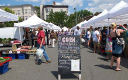 • Accommodate the Central Square Farmer's Market at its current site (improved), Jill Brown-Rhone Park or other suitable location in the event of redevelopment of current city parking lot location
Priority Streetscape and Active Edge Improvements
• Priority areas for developing/adapting buildings to include active ground floor uses include
o East side of Sidney Street at Lafayette Square (e.g. through replacement of the existing frame residential building. Retain historically/culturally significant structures).
o One or both sides of Sidney Street from Mass Ave to and along University Park Commons.
 o City parking lot edges, and other large parking lot frontage along streets/sidewalks
• Priority areas for other streetscape improvements include
o Install street trees and/or ornamental plantings in planters along Mass Ave between Prospect-Essex and Magazine-Pearl where below-grade obstructions prevent in-ground trees.
o Install green "biowalls" or public art where parking structure walls abut sidewalks, in particular along south-facing portions of the Green Street and Quest parking structures o Encourage the use of technology-based ideas for signage, wayfinding, and providing information
Parklets
 • Important near-term opportunities for high-impact, low-investment parklets involving business/organization program partners on underutilized sidewalk areas include, but are not limited to:
o Post Office plaza (consider USPS and/or Cambridge Senior Center as partner). Coordinate with adjacent Hubway station.
o Carl Barron Plaza and/or Western Ave opposite the Plaza (consider interactive information/arts theme including real-time transit information; MIT Media Lab, CAC, MBTA as sponsor?)
o Mass Ave opposite Norfolk Street (consider Dance Complex, with dance/healthy play theme, as partner)
o Mass Ave opposite Jill Brown-Rhone Park (consider Nora Theater, CCTV, Salvation Army, Forest City and/or Cambridge Fire Department as partner)
Goal 3: RETAIL, CULTURAL AND NON-PROFIT DIVERSITY
Expand retail & entertainment opportunities while celebrating and nurturing the mix of old, new, venerable and funky businesses and cultural institutions
| OBJECTIVE |
PROPOSED STRATEGIES (ZONING) |
PROPOSED STRATEGIES (NON-ZONING) |
| A. Reinforce the Central Square Cultural District as a vibrant retail and cultural destination for nearby neighborhoods and the city |
1. Encourage lively mixed-use activity in the Central Square core along Massachusetts Avenue between City Hall and Jill Brown-Rhone Park and the Osborn Triangle. Create incentives to encourage housing and expand the number of people supporting retail and cultural enterprises.
o Require ground floor retail (min. 20' depth) along Massachusetts Avenue.
o Require active ground floor uses along Main Street, designed to be converted to retail. Considerations include adequate ceiling height, accessibility, services, capacity to accommodate venting for restaurant use.
o Allow and encourage child care, arts uses, non-profit office space and similar community-serving uses where retail has limited market potential by exempting floor area of these uses from counting toward density limits; consider also allowing an equal amount of floor area as bonus density.
o Exempt ground floor retail floor area from counting toward density limits with dimensional constraints to provide diversity of retail and support local businesses.
o Permit and encourage second floor retail.
o Evaluate feasibility of making signage regulations more responsive to creative design, possibly through relaxing certain of the zoning standards.
2. Encourage public rooftop activite areas (away from neighborhoods) by allowing uses such as restaurants on top of hotels and publicly accessible green roofs and rooftop gardens. |
1. Promote the identity of the Central Square and the Central Square Cultural District.
2. Work with the CSBA, City agencies and other existing groups to expand capacity for and participation in Central Square management.
o Encourage further engagement of cultural organizations, neighborhoods and other stakeholders as well as businesses in CSBA initiatives.
3. Encourage creativity in the public realm
o encourage CSBA, businesses and property owners to partner with the City to create interesting, fun, public art that adds to the vibrancy of the Square.
o Relax signage control in the Central Square core to encourage creativity and foster a graphically interesting landscape.
4. Support the CSBA as it explores the feasibility of a Business Improvement District (BID) or other mechanish to enable sharing of resources expand management and funding capacity for initiatives such as marketing, cultural/community events, communications and tenanting support, fielding "ambassadors" in the square, cleanliness, adding and maintaining plantings etc.
o Review the strengths and limitations of existing management services provided by the CSBA, city agencies and other stakeholders.
o Define priority unmet needs.
o Determine whether a BID could effectively meet these.
o If a BID is feasible, create a business plan for the organization in coordination with the CSBA, city agencies and other stakeholders including residents. Identify interim opportunities to address any unmet management needs through expanded actions by the CSBA, City or other stakeholders.
5. Consider feasibility and impacts on businesses of expanding free, public wifi in Central Square. |
| B. Support an attractive and vibrant walking environment by keeping retail storefronts continuously occupied with active uses |
|
1. Work with CSBA, CAC, and property owners to expand opportunities for occupancy of temporarily vacant storefronts.
o Proactively work with owners of vacant spaces to suggest opportunities for installation of public art, temporary or "pop-up" retail, or other occupancy that contributes to the overall economic prosperity and character of the Square.
o Establish convenient mechanisms to help temporarily fund insurance, utilities and/or related costs that may impede short-term occupancy.
o Administer an annual storefront award program to encourage and recognize creative storefront displays. |
| C. Enable valued businesses and non-profit organizations to get started and maintain a long-term presence in the study area |
1. Provide incentives for community benefits like affordable space for retail and non-profit organizations by allowing modest density and/or height increases where appropriate.
o Consider requiring, in return for bonus density or as a condition of city parking lot redevelopment, a one-time up-front subsidy such as waived rent (e.g. for 6-12 months) or free fit-out of space for eligible businesses. As possible, invest the fit-out subsidy in building elements that would also have value for a future tenant should the first tenant fail within a limited time period (e.g. HVAC, kitchen facilities). Criteria for eligible businesses may include:
• Limitation on floor area of subsidized space
• Non-eligibility of formula retail formats associated with national chains (i.e. fast food)
• Limit on total number of outlets of eligible businesses
2. Remove fast food cap in Central Square. Instead, create new regulation to limit formula businesses. Pay particular attention to limit use of disposable, non-compostable serveware).
3. Verify costs and feasibility of rental of small market stalls (indoor and/or outdoor, including mobile cart opportunities) to merchants. Locate any market stalls in a highly visible, marketable area with significant passing pedestrian traffic such as adjacent to a major public plaza or public room. (see Public Places to Build Community)
o Consider requiring, in return for bonus density or as a condition of city parking lot redevelopment, creation and management of market stalls. These may be indoor or outdoor as judged to be most effective and feasible. |
1. Maintain and publicize an inventory of retail and office spaces, diverse in size, to help market spaces to potential new tenants, and to advise current tenants on opportunities for relocations.
o Work with CSBA and City to recruit and match desired retailers for available space.
2. Support local retail and restaurants through measures to encourage tourism such as accommodations for parking tour buses. |
Priority Retail Areas
Goal 1: INCREASE HOUSING STOCK AND PROMOTE RESIDENTIAL DIVERSITY
Add housing with special attention to affordable and middle-income choices to support community diversity and cultural and economic activity
| OBJECTIVE |
PROPOSED STRATEGIES (ZONING) |
PROPOSED STRATEGIES (NON-ZONING) |
| A. Expand housing stock and increase the range of housing choices to serve a broad spectrum of incomes, ages and household sizes |
1. Facilitate appropriate infill development and adaptive reuse by reducing or eliminating minimum parking requirements.
2. Update parking requirements so that existing developments may request reduced minimum parking requirements as part of development proposals (including adaptive reuse, infill development and/or more comprehensive redevelopment). Minimum parking requirements associated with existing development in some cases require property owners to maintain more parking spaces than are actually needed to meet typical demand. Reducing these requirements, consistent with the reduced parking requirements the city has typically applied in recent development proposals in response to increased use of transit, walking and biking, would discourage traffic growth in the study area and help create potential for higher-value uses serving community goals of the master plan.Continue to apply Cambridge's established inclusionary zoning program, which provides an incentive for developers to include affordable units in new development projects.
3. Incent development of middle-income family housing and additional affordable housing through all possible means including density bonus and conditions of city parking lot redevelopment.
o Affordable/middle-income/family housing strategies for consideration:
• Offer bonus density, beyond that offered by the inclusionary affordable housing policy, on the condition that the equivalent of at least 20% of the bonus floor area approved be devoted permanently to middle-income housing (see definitions at right). Any bonus density must be subject to the design guidelines. Recommended range of bonus density for consideration (beyond inclusionary bonus opportunity): up to 9% within existing zoning/overlay height limits, and up to 16% with potential height increases to approximately 10 stories or 100 feet in selected areas.
• Make development of middle-income housing a condition of sale of city parking lots for redevelopment. For example, prioritize sale to non-profit affordable housing developers, and/or require that at least 20% of all units developed under base allowed density be permanently dedicated as middle-income units.
• Average minimum middle-income unit size should meet CDD Housing Division parameters for family housing (e.g. at least 950 net square feet and 2 bedrooms).
4. Encourage development of housing in the Osborn Triangle, particularly along Main Street facing Area 4, as well as on the block contiguous with Jill Brown-Rhone Park.
o Enable transfer of bonus housing density within the Osborn Triangle area. Maintain existing 45' height limit and 45 degree upper floor setback plane at Main Street, while considering bonus height in the direction of Massachusetts Avenue.
o Create a housing incentive in Osborne Triangle along Main Street. Exempt floor area of any housing within 20' of Main Street from counting toward density limits.
o Take special note of Newtowne Court's proximity to the Osborn Triangle; ensure community input to development plans, especially along Main Street; ensure that any Main Street development better connects Newtowne Court to the neighborhood rather than walling it off.
5. Accommodate development of "micro-units" among the mix of housing types. Remove zoning and permitting barriers to "micro-unit" development; do not allow these to count toward family unit goals e.g. Adjust lot area/dwelling unit requirement. |
1. (see Leverage Future Public and Private Investments for more detail)
2. Develop the City parking lots with the proviso that full value of this City resource is returned through a broad program of public benefits including affordable and middle-income family housing and true public spaces
3. Identify privately owned lots and buildings in the Square that are either unused, or significantly under-utilized,and encourage alternative uses or development of these properties through zoning incentives and negotiations with owners |
Definitions of affordability for purposes of this plan:
o "Affordable" means that housing costs represent no more than 30% of a household's gross income
o "Affordable housing" refers to housing affordable by households earning 65% - 80% of Area Median Income (AMI) as defined by HUD.
[In 2012, 65% AMI for a family of four is $63,570, based on 100% AMI for a family of four being $97,800]
o "Middle-income" housing refers to housing affordable by households earning 80% - 120% of Area Median Income (AMI) as defined by HUD.
o "Family housing" refers to housing having 2 or more bedrooms and located with convenient access to private or shared outdoor space
o For more information, see Cambridge's Community Development Department Housing Division webpage, http://www.ci.cambridge.ma.us/CDD/housing.aspx
o Sample housing costs for a family of four people, 2012 (source: http://www.ci.cambridge.ma.us/CDD/housing/resourcesandadditionalinformation/housingprogramincomelimits.aspx) |
What impact can Central Square and the Osborne Triangle have on affordable housing opportunities in Cambridge?
The inclusionary zoning program has helped create more than 450 units of affordable housing across the city since its inception in 1998. If parking lots and other sites with significant untapped zoning capacity in Central Square and Osborne Triangle were redeveloped, as many as 100 or more additional affordable and/or middle-income housing units could potentially be created. |
Goal 4: CONNECTING PEOPLE TO THE SQUARE
Enrich neighborhood walkability and livability with safe, green streets and improved access choices.
| OBJECTIVE |
PROPOSED STRATEGIES (ZONING) |
PROPOSED STRATEGIES (NON-ZONING) |
| A. Enhance the street network to make walking more convenient, safe and fun |
1. Refine development and design guidelines, with emphasis on ensuring transparent retail storefronts; enhancing residential street edges and accessibility; activating side streets with appropriate retail and office uses; and defining appropriate transitions of scale, land use and character between the study area and adjacent neighborhoods.
o See details on page 13
o Include design guidelines to establish and improve pedestrian connections -- within the square, and to the neighborhoods.
2. Enable appropriate infill development and adaptive reuse by reducing obsolete minimum parking requirements. See below. |
1. Plant street trees where possible, and encourage gardens along residential uses on side streets.
o Plant street trees in available locations where they are missing. Where lack of adequate soil quantity or quality prevents healthy tree growth, create linear tree trenches along the curb to aid root growth and water infiltration. Add irrigation where necessary, preferably utilizing retained stormwater.
o Consider installing trees and/or smaller ornamental plantings along both sides of Massachusetts Avenue in the first block east of Prospect and Magazine where vaults and other below-grade obstructions have prevented installation of any street trees. Strategies include:
• Placing trees in planters can be an alternative where below-grade conditions preclude in-ground planting. Select a consistent planter design that contributes to overall identity of Central Square. City and CSBA will need to partner on maintenance and watering.
• Where properties with below-sidewalk vaults are redeveloped or substantially renovated, require vaults to be removed and replaced with street trees where locations allow.
o Apply design guidelines to encourage small front gardens, 5 to 10 feet deep from sidewalk to principal façade line, along residential building frontage on streets other than Massachusetts Avenue and Main Street. Stoops and bay windows may protrude into this garden area. Where sidewalks lack adequate space for street trees, the 5-10 foot garden dimension may be applied instead to create a tree zone between the clear sidewalk passage and the curb.
2. Widen sidewalks where widths are inadequate to accommodate pedestrian flow.
o Widen the Magazine Street sidewalk at Carl Barron Plaza and adjacent bus stops as much as possible without impeding bus operations.
3. Improve pedestrian street lighting with a plan that addresses safety, convenient access to evening cultural and dining destinations, and identity.
4. If existing parking lots are redeveloped, require creation of walkable, friendly ground floors and site edges. |
| B. Maintain and improve a variety of good transportation choices |
|
1. Work with the MBTA to introduce real-time transit service information signage in/near Carl Barron Plaza and/or nearby bus stops and Red Line station entrances, including bus schedule information.
o Collaborate with the CAC, MIT Media Lab and/or other partners as well as the MBTA to make information a signature experiential/identity element as well as a practical one.
2. Enforce traffic ordinances to minimize conflict between vehicles, cyclists and pedestrians.
3. Monitor pedestrian and vehicle flow/conflict impacts of new development in critical locations, such as at Magazine Street and Mass Ave.
4. Review all signage at Mass Ave/Prospect/River/Western Ave to provide better guidance to vehicles. |
| C. Update parking requirements to reflect increased preferences for alternatives to driving |
1. Define fixed parking maximums and flexible minimums (based on analysis and as approved by Planning Board) for all uses per table on opposite page.
2. Accommodate shared parking where feasible.
3. See also Residential Diversity for application to existing development. |
1. Review parkign meter/parking lot payment policies to provide consistency.
2. Evaluate adoption of technology-based payment solutions including credit card and pay by cellphone.
3. Identify and eliminate policies that subsidize automobiles. |
| D. Add plantings and green infrastructure to encourage a healthier environment |
1. Require on-site management of stormwater. |
1. Add stormwater retention and infiltration infrastructure where appropriate to address flooding and water quality challenges.
o Create a stormwater facility near Jill Brown-Rhone Park, coordinated to accommodate associated development and/or public open space on-site.
o Utilize stormwater management measures e.g. rain gardens along streets where they can effectively aid stormwater management. Encourage adjacent property or business owners to help maintain rain gardens.
o Increase on-site retention and cleansing of stormwater in new development and adaptive reuse through encouragement of green roofs, cisterns, rain gardens and/or related strategies as appropriate. |
FOSTER A SUSTAINABLE FUTURE FOR CENTRAL SQUARE
Continue to promote sustainability in planning, design, and development
1. Encourage smart growth via a mix of uses, with special emphasis on housing within 1/2 mile of Central station.
2. Encourage use of walking, bicycling, and transit. Continue to support options such as car-sharing and bike-sharing so people who live in Central Square can live comfortably without owning a car.
3. Proposed sustainable development measures (to be updated, as needed, to reflect advancement of state-of-the-art sustainability strategies and achievements):
• All commercial development within the study area that is subject to Sec. 22.20 (Green Building Requirements) of the Cambridge Zoning Ordinance must meet LEED criteria at the Gold level.
• Commercial buildings must track energy using Energy Star, Labs21, or LEED-EBOM tools and methodologies and must report energy use to CDD on an annual basis for 5 years after the building is occupied. Residential buildings are encouraged to follow these steps as well.
• (Re)development must meet the DPW standard for water quality management and the retention/ detention of the difference between the 2-year 24-hour pre-construction runoff hydrograph and the post-construction 25-year 24-hour runoff hydrograph. Low impact development strategies are particularly encouraged as a means to meeting this standard. (existing DPW standard to be included in zoning)
• Development proposals in the Osborn Triangle must include a study of the technical and cost feasibility of utilizing the district steam system to provide heating energy for new or existing buildings in the PUD.
• Planning Board may allow dimensional or other zoning relief to allow co-generation and other energy systems that allow developments to utilize waste heat and other shared solutions to minimize energy loss.
• Enhance property owner awareness of incentive programs for insulation, historic restoration and other means of achieving better environmental performance with existing buildings
4. Use future buildings, site planning, and public realm design to reduce heat island effect.
• Require Cool roofs (green or white)
• Encourage green walls
• Encourage trees, greenery throughout, both in public space and as part of private development
5. Encourage advancement of green building criteria by revising standards as better tools become available with advancements in technology and application. |
To achieve the vision goals, LEVERAGE FUTURE PRIVATE AND PUBLIC INVESTMENTS, as appropriate.
Mitigate any neighborhood impacts such as traffic, noise, shadows, or inappropriate scale.
| OBJECTIVE |
PROPOSED STRATEGIES (ZONING) |
PROPOSED STRATEGIES (NON-ZONING) |
| A. Apply criteria to achieve community benefits if city parking lots are redeveloped |
|
1. The land currently used for public parking lots is a unique public asset in Central Square. Redevelop these public parking lots according to criteria that help advance the vision for the Square. Priority public benefits to be considered for the parking lots and potential redevelopment of other public property in the area include one or all of the following:
o Creative, new public space that fosters community and supports arts and programming -- outdoor (e.g. plaza, park) or indoor (public room/gathering space, public market, possible uses such as relocated Central sq library).
o Mixed income housing – including a significant component affordable to middle income and low/moderate income residents, including 2-3 bedroom units designed for families.
o Affordable retail and non-profit space especially focused on arts and culture.
o Other goals indicated among the strategies in other sections of this plan.
o Redevelopment should improve public edges along streets and sidewalks and enhance walkability and connections between the Square and adjoining residential neighborhoodsSuch redevelopment will require accommodation of short-term public parking either as part of the redevelopment on each site or evaluation of short-term public parking needed to support the Square based on creating a consolidated parking facility – below grade or above grade, faced with active edges at street level if this is needed to release the remaining lots for desired redevelopment. Traffic impacts of such consolidation and optimal amount of parking spaces to be replaced must be evaluated at the time such a solution is contemplated to match supply to need based on changing behavior over time. |
| B. Ensure accountability with respect to public benefits |
|
1. Create a mechanism to record, update, and monitor public benefits commitments by developers that is transparent and easily accessible to the public. Implement measures to monitor compliance and enforcement.
2. In considering alternative means of reaching a goal, for example creation of 'public' space in a new development, select the means that retains the most control for the City. |
****Please check next page (below) for analog images illustrating the VISION FOR FUTURE TRANSFORMATION OF THE MUNICIPAL PARKING LOTS to achieve the public benefits identified in this plan. A more detailed plan of how the parking lots may serve as a collective set of assets to achieve these goals should be developed.
ZONING RECOMMENDATIONS
CENTRAL SQUARE OVERLAY DISTRICT: Expand Overlay District to encompass 'Heart of Central Square' and 'Osborn Triangle' area shown on the diagram.
Character of the sub-areas are very different now and are expected to continue to be different over time.
Heart of Central Square serving as Cambridge's downtown business and retail center
Osborn Triangle area serving as a complex mixed use connective tissue between the technology focused office and lab development in Kendall Square/University Park/Novartis and the Area 4 residential neighborhood as well as the Heart of Central Square commercial downtown area. It is expected that this area will evolve to include a mix of uses including residential, office and lab uses, with active ground floors. (Re)development in this area will have a higher burden of placemaking through creating active ground floors in key locations, new connections, and incorporating public realm improvements.
Neighborhood Edges, which fall within both the Heart and Osborn Triangle areas, are areas adjacent to the traditional Cambridge low-scale residential neighborhoods and future development in these areas should pay particular attention to the transition, in terms of use, scale, and building/site design.
BASE ZONING DISTRICTS: No Change
OVERLAY DISTRICT PROVISIONS: Available by Special Permit at the Planning Board
FAR Non-Residential: Retain at 2.75 Residential: Increase to 4.0*
MAXIMUM HEIGHT
Heart of Central Square: Non-residential: 80' Residential: 140' with floorplate above 80' limited to 10,000 sf*
Osborne Triangle: Non-res: 100'** Residential: 160' with floorplate above 100' limited to 10,000 sf*
Neighborhood Edges: Maintain base and SP FAR and heights as under current zoning and overlay provisions. Maintain 45' height abutting residential districts and 45 degree bulk control plane for all uses, to begin at parcel line.
* (1) Middle-income component required (2) On sites over 40,000 sq. ft., height over 80'/100' limited to 25% of site area.
** In parcels with IB base, district permits higher heights than noted here, development to the base district height limit may be permitted.
HOUSING
• Encourage housing creation throughout the area, with emphasis on middle-income housing.
• Only housing permitted at heights above:
– 80' in Heart of Central Square
– 100' in Osborne Triangle
– 120' in portions of the Osborn Triangle with IB base district
• 25% of residential units above the base FAR and heights noted above to be dedicated to middle-income. Generally family units (2-3 BR) are preferred in this category, unless incompatible with remaining building use.
• Allow balconies (up to a depth of 5') to be exempted from counting towards the permitted GFA.
PUBLIC BENEFITS to be emphasized during special permit considerations
• Active ground floors
• Diverse retail – designed to appeal to independent retailers rather than large chains e.g. small floorplates and
• Increase housing stock – focus on middle income housing incl. family size units
• Encourage creation of public plazas and parklets
• Encourage office space appealing to (and affordable to) non-profits e.g. second floor space
ENHANCED PUBLIC BENEFITS Key considerations for the City Council when consider additional density and height over and above these recommendations on a case by case basis:
• Impact on neighborhood edges & residential neighborhoods
• Nature/amount of benefits e.g.
− significant public space (indoor/outdoor),
− increased middle income and/or affordable housing
− enhanced retail support e.g. fitout assistance/reduced rents for min. time period
− reduced rents for non-profits |
TRANSFER OF DEVELOPMENT RIGHTS (TDR)
Create a new TDR provision to address the following goals:
• Lower density in and adjacent to low-density residential neighborhoods
• Protection of historic buildings
• Improve housing production in areas within the core of Central Square and Osborn Triangle
Mechanism
• Allow GFA transfer from Donating Districts to Receiving District and among parcels within the Receiving District. (SP FARs used for calculation)
• Would require special permit from the Planning Board showing plan for both the donating and receiving parcel.
• Transfer of partial GFA may be permitted
– If 100% of the GFA permitted on a site is being transferred, then use on donating lots may be public open space or middle-income housing at 0.75 FAR (within BB or IB base districts) or 0.5 FAR (all other districts)
• Allow GFA transfer among sites within Receiving District
– Transferred GFA may be used for housing only, although middle-income component is not required for transferred GFA
• Allow additional 20 ft. height to accommodate transferred GFA
RETAIL DIVERSITY & NON-PROFIT SPACE
• Require ground floor retail along Mass Ave and active ground floor uses convertible to retail along Main St
• Exempt ground floor and basement retail and ground floor daycare, non-profit space and public space from counting as GFA (within Overlay District) if:
− Min. 30% GFA must be floorplates of 1,500 sf. or less
− Max. 30% GFA may be floorplates of over 5,000 sf. or larger
− For buildings with frontage greater than 50', 60% of the frontage must be devoted to storefronts with a average frontage of 30 ft. (not including ATMs in the calculation)
− Relax criteria to accommodate daycare, indoor public room, public pedestrian/bike connections, non-profit space, and retail and retail-support (e.g. storage) space in the basement
− Planning Board to have flexibility to approve variations if they meet the sprit of these criteria
• For Storefronts vacant for 6 months or more, property owners must work w/ City, CSBA, local non-profits to provide short-term popup, arts, cultural, non-profit, or community uses
• Encourage affordable office space along remaining streets to cater to non-profits and small businesses
− Bishop Allan Drive,
− Green St
− perpendicular streets within a block of Mass Ave
• Encourage live-work housing models on ground floor along Bishop Allen Drive
• Remove impediments to new retail
− Eliminate fast food cap. Instead, create new regulation to limit formula businesses. (Pay particular attention to limit use of disposable, non-compostable serveware ) |
TRANSPORTATION RECOMMENDATIONS
| GENERAL ISSUES |
| CATEGORY |
ISSUE |
RECOMMENDATION |
SCHEDULE (SHORT, MEDIUM, LONG-TERM, ON-GOING) |
| A. Character and Streetscape |
1. Reduce Mass Ave character as a thoroughfare.
2. Need grand vision and cohesive design strategy. Need more trees/green - feels barren and unpleasant to walk.
3. Cars dominaten – Central Sq should be a place, not a jumble of cars.
4. Streets parallel to Mass Ave shouldn't feel like alleyways. |
1. When Mass Ave is reconstructed consider interventions such as reallocation of ROW to strengthen peds, bikes, and transit facilities. |
Long-Term |
2. Refer to Design Guidelines for additional information on street/sidewalk environment |
Short – long term depending on pace of (re)development |
| B. Conflicts among all modes |
1. Can we separate the various transportation modes to enhance safety and improve flow? |
1. When Mass Ave is reconstructed consider interventions such as reallocation of ROW to strengthen peds, bikes, and transit facilities. |
Long-Term |
| C. Transit |
1. Improve MBTA Red Line and bus transit capacity and frequency to continue to accommodate growth in Cambridge and the broader region
2. Increase effectiveness of the bus network -- ridership, rider experience, and efficiency. Evaluate creating a bus depot
3. People waiting for buses take up space on the sidewalks and reduce space available for open space and pedestrian circulation, especially at key pinch points. Decrease impact of buses and bus stops on public space and sidewalks
o Move stops off Mass Ave, move stops off Green/Magazine corner.
o Bus only streets without cars.
o Crowded sidewalk at bus stop waiting area by Convenience Store. |
1. City, business association, residents and all stakeholders must advocate for continued MBTA systemwide infrastructure improvements, with special emphasis on enhancing Red Line capacity
2. Based on preliminary evaluation, bus depot is not recommended |
Ongoing/Long-term |
3. Work with MBTA and property owners to have next bus info being displayed at the bus stops and/or in nearby stores
|
Short to medium-term |
4. Work on a study with the MBTA to look at routing, layover and stops changes for the Central Square buses. One goal would be to look at ways to reduce the crowding from people waiting for the bus at this location. The City is interested in having the route 70 and 70A buses extended to Kendall Square. |
Medium-term |
| D. Off-street Parking Requirements |
1. Define fixed parking maximums and flexible minimums (based on analysis and as approved by Planning Board) for all uses
2. Accommodate shared parking where feasible
3. Require shared parking study for mixed use projects
4. Investigates ways to remove regulatory impediments (City and State) to reduction and sharing of existing parking |
| Recommended parking space requirements |
| Use |
Minimum |
Maximum |
| R&D |
Based on analysis |
0.8 sp/KSF |
| Office |
0.9 sp/KSF |
| Retail /consumer service |
0.5 sp/KSF |
| Residential |
0 space/dwelling unit for studio/micro units
0.5 space/dwelling unit for 1-BR or larger units*** |
0.75 space/dwelling unit |
| ***Several Committee members recommend that the minimum parking requirement should be 0 sp/du for all Residential use |
|
Short-term |
| E. Support non-auto modes of transportation |
|
1. Continue to improve bicycling infrastructure by moving towards an environment where bicycles and vehicles are on equal footing (with a specific focus on Massachusetts Ave from Inman Street to Portland Street)
2. Continue to improve signage for both bikers and pedestrians
3. Evaluate the feasibility of closing some side streets to vehicular traffic during high-congestion hours to encourage alternative bike routes and prevent neighborhood cut-throughs by automobiles |
|
| F. Enforcement |
1. Roadway users do not travel carefully and cause conflicts. Among the issues:
o motorists not yielding to pedestrians/bicyclists while turning;
o motorists not yielding to peds at crosswalks;
o motorists running red lights; motorists opening car doors;
o pedestrians jaywalking;
o cyclists not yielding to peds in crosswalks;
o cyclists on sidewalk;
o cyclists running red lights. |
1. Stricter enforcement
o of automobile moving violations
o ticket bicycles and peds at signals and unsignalized crosswalks.
o ticket Jay walkers.
2. Combine enforcement with education via a variety of media.
3. Cars run red lights -- could be addressed with camera enforcement. |
Ongoing |
| G. Illegal parking |
1. Illegal parking in general such as delivery trucks in bicycle lanes, non-residential parking in resident only areas at night. |
1. Enforce at hot spots and evaluate problem areas for curb regulation changes. Examples include providing additional loading zones where warranted to prevent delivery truck in bicycle lanes. Also work with businesses on delivery schedules and locations. |
Short-Term and On-Going |
| H. Trucks |
1. Oil tankers are not compatible with Central Sq character |
1. River, Western, Pleasant, Massachusetts, and Main St are designated regional truck routes. City cannot restrict trucks without State approval as part of a regional plan. City has been unsuccessful in finding alternate routes that will satisfy regional requirements. |
|
| I. Non-MBTA transit |
1. LMA shuttles loud and not energy efficient. |
1. City has conveyed this concern to the Medical Area Scientific Community Organization (MASCO) which operates shuttles. New buses would be required to address noise concern. |
|
| J. Signage |
1. In general, the environment feels cluttered with too many signs and this creates confusion. In particular, the special signs installed at Mass/River/Western are confusing. |
1. Review Central Sq signage and identify opportunities for reducing/improving signage. Note that many of the signs are there because of requests from the public and businesses who want them there. |
Short to Medium-Term |
| LOCATION SPECIFIC ISSUES |
| LOCATION |
ISSUE |
RECOMMENDATION |
SCHEDULE |
| Massachusetts Avenue |
1. Bicycling on Massachusetts Avenue is difficult due to
o illegal parking in bicycle lanes
o dooring
o buses stopping in bicycle lanes rather than pulling to curb,
o trucks, buses and cars pulling into and out of the bicycle lanes.
2. At Mass and Prospect peds conflict with right turning vehicles on Mass Ave east side crosswalk.
3. Route 1 bus too slow and too crowded. |
1. Long-term reconstruction should create a separated bicycle facility/cycle track. |
Long-Term |
2. Increase enforcement of illegal parking in bike lanes
3. Massachusetts Avenue northside between Prospect and Temple Street - move HP spot to Temple and make the block a loading zone.
4. Mass Ave southside Inman to Temple make a loading zone 7am to 11am, relocate HP space. |
Short-Term |
| Pleasant Street @ Massachusetts Avenue |
1. Pedestrians crossing at Pleasant Street/through cyclists on Massachusetts Avenue conflict with motorists coming from Inman Street to Pleasant.
2. Westbound stop line on Mass so far back that cars running the yellow conflict with the pedestrians crossing with the walk light. |
1. Evaluate potential signal or crosswalk changes to reduce or eliminate conflict.
2. TP&T work is underway to add a signal head so that the stop bar for westbound Mass can be moved to Inman St. Eastbound bicycle lane to be marked through the Pleasant St intersection. |
Short-Term |
| Mass @ Inman |
Mass crossing at 26 sec feels too short, Inman crossing is twice as long. |
Mass. Avenue is the major roadway and has longer green time than Inman Street which permits additional pedestrian crossing time of Inman Street. Time for pedestrian crossing of Mass. Avenue was extended in 2011 in coordination with the Senior Center, and currently provides more pedestrian crossing time than national standards require. |
On-Going |
| Inman @ Bishop Allen Drive |
Can we add a crosswalk for the people going to and from the Food Pantry? |
This is not recommended. The addition of a crosswalk at this location would either eliminate the loading zone for the Food Pantry or eliminate 2 resident permit spaces depending on which side of the intersection it was placed on. |
|
| Pleasant @ Western |
This feels like a hazardous crosswalk, seems safer to jaywalk mid block. |
Plan for improvement created through Western Ave planning process |
Short-Term |
| Pleasant @ River |
|
In DPW 5-year street reconstruction plan. Improvements will be evaluated and implemented as part of that plan. |
|
| Temple Street |
Pedestrian crosswalk east of Temple Street is difficult to see at night. |
Highlight this issue to be addressed in lighting plan for Central Sq as part of the City's LED conversion |
|
| Green Street @ River & Western |
Awkward pedestrian crossing of River and Western on south side of intersection. |
When construction is scheduled for the intersections, signal changes in combination with infrastructure changes will be possible to improve this intersection for pedestrians. Actual change would have to be designed. |
Medium to Long-Term |
| Western Avenue @ Franklin Street |
Lack of crosswalk on southern leg of Western Avenue at Franklin Street. |
New crosswalk will be added as part of the City's Western Avenue reconstruction project. |
Project underway |
| Green Street at Magazine Street |
Motorists ignore stop sign and don't yield to pedestrians at this intersection. |
It is extremely difficult to get all cars to stop at the stop sign at Green/Magazine when the signal at Green/River is green, given the short distance between the stop sign and the signal. |
Medium to Long-Term |
| Green @ Magazine Street |
Poor snow clearance at Green and Magazine for peds. |
Work with DPW and property owners to improve snow clearance on sidewalk |
On-Going |
| Green @ Pearl |
Crowded sidewalk at bus stop on Green Street at Pearl waiting for 70 and 70A. |
The City will be working on a study with the MBTA to look at routing, layover and stops changes for the Central Square buses. One goal would be to look at ways to reduce the crowding from people waiting for the bus at this location. The City is interested in having the route 70 and 70A buses extended to Kendall Square. |
Medium to Long-Term |
| Essex Street and Norfolk Street |
Limited greenery and narrow sidewalks make unattractive pedestrian connections between Area 4 and Central Square |
Work with the City Arborist to find additional appropriate locations for trees and other green elements to improve pedestrian environment |
Short to Medium-term |
| Essex Street and Bishop Allen Drive |
Unattractive surface parking lots. |
TP&T will work to improve asthetics in City Lots, which currently have Murals and landscaping. |
Medium to Long-Term |
| Pearl Street @ Massachusetts Avenue |
1. Pedestrian crossing Pearl/through cyclistsconflict with left turning cars.
2. Vehicles cut through from Norfolk to Pearl.
3. So many things happening it is hard to know where to look. Can we ban left turn into Pearl? |
No changes to this location have been identified. The traffic move from Norfolk to Pearl provides an option for residents crossing Central Square that is strongly supported. TP&T will review the crash history at this location. |
|
| Pearl Street between Massachusetts Avenue and Franklin Street. |
1. Narrow sidewalks and lack of shade on Pearl Street.
2. Poor pedestrian environment due to blank walls and limited ground floor activity. |
Create new frontage at library |
Long term |
| Pearl Street & Upper Brookline Street |
1. Illegal parking on Pearl Street prior to loading zone blocks buses.
2. Loading activity on Brookline Street obstructs travel lane. |
1. Create enforcement priority hot spots.[would you consider pavement markings saying "no stopping"; don't know if they work] |
Short-Term |
| 2. Review Green Street signage. |
Short-Term |
| Brookline @ Mass |
Ped crossing in the middle of the Brookline to Douglas vehicles. |
The current location of the crosswalk has been found to be better than alternative locations which would either lead to higher levels of conflicts or the loss of highly used, short-term parking spaces in front of businesses. |
|
| Unsignalized crosswalk by Salvation Army |
Lack of yielding by motorists |
Yield to peds sign has been placed in the center of the roadway. Salvation Army responsible for maintaining yield barrel. |
On-Going |
| Columbia Street & Lafayette Square |
1. Very long crossing of Sidney Street extension for pedestrians.
2. Lack of yielding at Columbia Street and Lafayette Square.
3. Desire for street space for special events.
4. Main St bike lane leads bikes in Lafayette Square, conflicting with park users. |
1. Would need to rebuild. |
Long-Term |
| 2. Install bicycle box and mark left turn movement for bicycles on Main Street westbound onto Sidney St. Extension. |
Short to Medium-Term |
| Main Street & Front Street & Windsor Street |
1. Windsor Street sidewalk is narrow.
2. Lack of pedestrian connection between Main Street and Massachusetts Avenue from Windsor Street to Sidney Street extension. |
1. Novartis project will improve walkability of Windsor Street. |
Ongoing |
2. Design guidelines to encourage connection – implemented via project review |
Short term |
| Albany Street & Portland Street |
The intersection is awkward for all users and has a poor connection to the railroad crossing to Vassar Street. |
New design(approved by the City) will be implemented as part of the 610-650 Main Street development project. |
Ongoing |
| Green St Garage |
Green St garage is not popular with motorists and is sub-optimal in it's connection to the street and public realm |
Consider full range of options including
o Tear it down to accommodate other possible uses needed to streamline bus operations or other amenities for Central Sq
o Enlarge to consolidate parking for Central Sq – this poses structural issues and may require demolition and reconstruction; traffic impacts on Green St will also need to be evaluated |
Long-Term |
| Blanche St |
Unattractive pedestrian environment |
Design guidelines for streets and sidewalks and potential future development on adjacent parcels |
Short-term |