Refiled Zoning Petition - Grand Junction Pathway Overlay District
May 15, 2019
Donna Lopez
City Clerk
City of Cambridge
795 Massachusetts Avenue
Cambridge, MA 02139
Re: Refiled Zoning Petition - Grand Junction Pathway Overlay District
Dear Ms. Lopez:
As our November 29, 2018 petition has expired, please find enclosed for filing, on behalf of Alexandria Real Estate Equities, Inc., and the owners of affected land, an updated zoning petition proposing the Grand Junction Pathway Overlay District.
Our November 29, 2018 petition has been revised to reflect input from interested parties. Key changes include lowering of proposed building height, the addition of a transition zone for building height and a decrease in project density.
We look forward to continuing the review process and are eager to revitalize the affected land and advance the Grand Junction Pathway.
Thank you for your consideration.
Very truly yours,
Joseph T. Maguire
Senior Vice President--Real Estate Development & Asset Services
Alexandria Real Estate Equities, Inc.
Grand Junction Pathway Overlay District Zoning Amendment
The undersigned owners of land to be affected by this Petition, hereby petition the Cambridge City Council as follows:
1. To see if the City Council will vote to amend the Zoning Map of the City of Cambridge as follows:
Parcel 1. A certain parcel of land situated in the City of Cambridge, County of Middlesex and the Commonwealth of Massachusetts more particularly described as follows: Beginning at a point at the intersection of the westerly sideline of Fulkerson Street and the northeasterly sideline of Binney Street; thence running N 56°29'27" W, by said Binney Street, a distance of 226.55 feet to a point; thence turning and running N 57°11'37" W, by said Binney Street, a distance of 51.81 feet to a point; thence turning and running N 10°45'15" E, by land now or formerly of Massachusetts Department of Transportation, a distance of 1014.59 feet to a point; thence turning and running S 80°27'41" E, by land now or formerly of Spring Condominium, a distance of 83.70 feet to a point; thence turning and running S 09°32'21" W, by land now or formerly Pay Phone Realty Trust, and land now or formerly of NSTAR Electric Company, a distance of 278.56 feet to a point; thence turning and running S 06°22'09" E, by land now or formerly of NSTAR Electric Company, a distance of 127.16 feet to a point; thence turning and running N 12°47'39" W, by land now or formerly of NSTAR Electric Company, a distance of 76.39 feet to a point of non-tangency; thence running by a curve to the left, having a radius of 301.06 feet, a chord bearing of S 28°33'33" E, a chord distance of 138.60 feet, a delta angle of 19°01'53", and an arc length of 139.85 feet, by land now or formerly of NSTAR Electric Company to a point on said Fulkerson Street; thence running S 09°32'20" W, by said Fulkerson Street, a distance of 546.29 feet to the point of beginning; said parcel of land containing an area of 191,506 square feet or 4.39 acres; and
Parcel 2. A certain parcel of land situated in the City of Cambridge, County of Middlesex and the Commonwealth of Massachusetts more particularly described as follows: commencing at a point at the intersection of the westerly sideline of Fulkerson Street and the northeasterly sideline of Binney Street; thence running N 56°29'27" W, by said Binney Street, a distance of 226.55 feet to a point; thence turning and running N 57°11'37" W, by said Binney Street, a distance of 90.66 feet to the point of beginning; thence running N 57°11'37" W, by said Binney Street, a distance of 15.11 feet to a point; thence turning and running N 10°45'15" E, by land now or formerly of ARE-MA Region No. 58, LLC, a distance of 508.00 feet to a point; thence turning and running S 67°21'26" E, by Parcel 3 herein described, a distance of 14.31 feet to a point; thence turning and running S 10°45'15" W, by land now or formerly of Massachusetts Department of Transportation, a distance of 510.72 feet to the point of beginning; said parcel of land containing an area of 7,131 square feet; and
Parcel 3. A certain parcel of land situated in the City of Cambridge, County of Middlesex and the Commonwealth of Massachusetts more particularly described as follows: beginning at a point on the westerly line of land now or formerly of Massachusetts Department of Transportation said point being S 10°45'15" W, a distance of 510.72 feet from the northeasterly sideline of Binney Street; thence running N 67°21'26" W, by Parcel 2 herein described and land now or formerly of ARE-MA Region No. 58, LLC, a distance of 17.69 feet to a point; thence turning and running N 10°46'42" E, by land now or formerly of Richard D. Fanning, Wellington Harrington Memorial Way, and land now or formerly of John Frazier, Trustee, a distance of 743.27 feet to a point; thence turning and running S 80°25'39" E, by land now or formerly of Roman Catholic Archbishop of Boston, and Parcel 4 herein described, a distance of 17.00 feet to a point; thence turning and running S 10°45'15" W, by land now or formerly of Massachusetts Department of Transportation, a distance of 747.26 feet to the point of beginning; said parcel of land containing an area of 12,785 square feet; and
Parcel 4. A certain parcel of land situated in the City of Cambridge, County of Middlesex and the Commonwealth of Massachusetts more particularly described as follows: beginning at a point on the southerly sideline of Cambridge Street, S 80°29'15" E a distance of 130.97 feet from the easterly sideline of Cardinal Medeiros Avenue; thence running S 80°29'15" E, by said Cambridge Street, a distance of 6.19 feet to a point; thence turning and running S 11°03'38" W, by land now or formerly of Massachusetts Department of Transportation, a distance of 264.00 feet to a point; thence running along a curve to the right, by land now or formerly of Massachusetts Department of Transportation, having a radius of 784.50 feet, a chord bearing of S 13°46'27" W, a chord distance of 74.29 feet, a delta angle of 05°25'41", and an arc length of 74.32 feet, to a point; thence with a reverse curve to the left, by land now or formerly of Massachusetts Department of Transportation, having a radius of 1315.50 feet, a chord bearing of S 13°37'16" W, a chord distance of 131.60 feet, a delta angle of 05°44'02", and an arc length of 131.65 feet, to a point; thence running S 10°45'15" W, by land now or formerly of Massachusetts Department of Transportation, a distance of 59.81 feet to a point; thence turning and running N 80°25'39" W, by Parcel 3 herein described, a distance of 14.00 feet to a point; thence turning and running N 10°45'15" E, by land now or formerly of Roman Catholic Archbishop of Boston, a distance of 60.10 feet to a point; thence running along a curve to the right, by land now or formerly of Roman Catholic Archbishop of Boston, having a radius of 1329.50 feet, a chord bearing of N 13°37'16" E, a chord distance of 133.00 feet, a delta angle of 05°44'02", and an arc length of 133.05 feet, to a point; thence with a reverse curve to the left, by land now or formerly of Roman Catholic Archbishop of Boston, having a radius of 770.50 feet, a chord bearing of N 13°46'27" E, a chord distance of 72.97 feet, a delta angle of 05°25'41", and an arc length of 72.99 feet, to a point; thence running N 11°03'38" E, by land now or formerly of Roman Catholic Archbishop of Boston, a distance of 213.61 feet to a point; thence turning and running S 80°29'15" E, by Parcel 5 herein described, a distance of 8.06 feet to a point; thence turning and running N 10°46'42" E, by Parcel 5 herein described, a distance of 50.01 feet to the point of beginning; said parcel of land containing an area of 7,020 square feet; and
Parcel 5. A certain parcel of land situated in the City of Cambridge, County of Middlesex and the Commonwealth of Massachusetts more particularly described as follows: beginning at a point on the southerly sideline of Cambridge Street, S 80°29'15" E a distance of 78.39 feet from the easterly sideline of Cardinal Medeiros Avenue; thence turning and running S 80°29'15" E, by said Cambridge Street, a distance of 52.58 feet to a point; thence turning and running S 10°46'42" W, by Parcel 4 herein described, a distance of 50.01 feet to a point; thence turning and running N 80°29'15" W, by Parcel 4 herein described and by land now or formerly of Roman Catholic Archbishop of Boston, a distance of 51.41 feet to a point; thence turning and running N 09°26'25" E, by land now or formerly of Roman Catholic Archbishop of Boston, a distance of 50.00 feet to the point of beginning; said parcel of land containing an area of 2,600 square feet; be rezoned to create a new overlay zoning district entitled the Grand Junction Pathway Overlay District.
2. To see if the City Council will vote to amend Article 20 of the Zoning Ordinance of the City of Cambridge by adding the following text at the end of Article 20 as presently ordained:
20.1000 Grand Junction Pathway Overlay District
20.1001 Establishment and Scope.
There is hereby established the Grand Junction Pathway Overlay District, which is governed by the regulations and procedures specified in this Section 20.1000. It is the intent of this Section that these regulations will apply to land within the Grand Junction Pathway Overlay District, which is comprised of Grand Junction Land and Development Land, as defined below.
20.1002 Purpose.
It is the purpose of the Grand Junction Pathway Overlay District to augment base zoning and promote the development of a public pathway along the Grand Junction railroad right-of-way in connection with high quality development consistent with development along the Binney Street corridor.
The October 2001 East Cambridge Planning Study identified the Grand Junction corridor as a means to provide a significant transportation and recreational resource and enhance non-auto mobility in the City. The October 2006 Grand Junction Rail-with-Trail Feasibility Study highlighted the public benefits of the pathway, including recreation and open space, but noted that acquiring rights in the land to develop the pathway was a key limiting issue. The August 2017 Final Report ofthe Kendall Square Mobility Task Force underscored the impmiance of enhancing non-auto mobility in the City and the Grand Junction Pathway in meeting that goal.
The Grand Junction Pathway Overlay District will facilitate the City's efforts to secure long term public access to certain land in the Grand Junction Pathway Overlay District by incenting development consistent with development along the Binney Street corridor. A project meeting the requirements of this Section will provide open space, recreational opportunities, a corridor for non-auto traffic in the City, as well as high quality development, and promote the goals of public health, safety, welfare and economic development.
20.1003 Applicability.
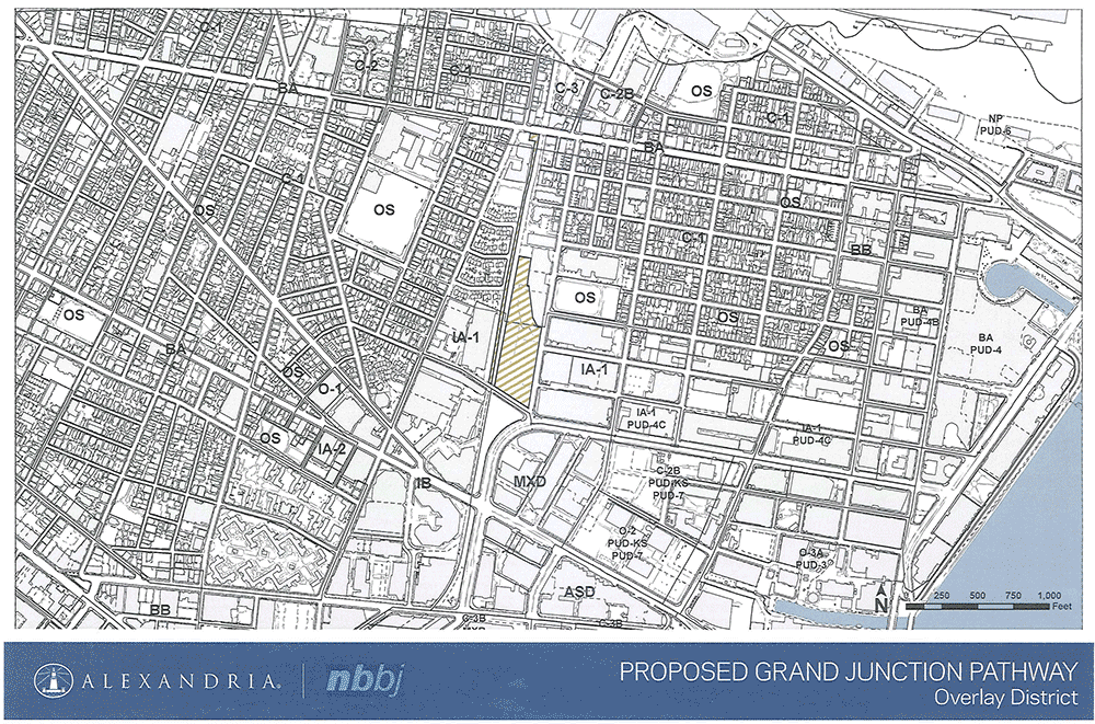
Development in the Grand Junction Pathway Overlay District shall be controlled by the regulations governing the Industry A-1 District, except as modified by the requirements of this Section 20.1000, which shall apply in lieu of the regulations of the Industry A-1 District. Where the regulations applicable to the Industry A-1 District differ from the requirements of this Section 20.1000, the provisions of this Section shall apply. The Grand Junction Pathway Overlay District shall be established on the Zoning Map of the City of Cambridge pursuant to the provisions of Section 3.20.
20.1004 Procedure.
Construction, use and development under this Section shall be authorized by Special Permit granted by the Planning Board. In granting a Special Permit under this Section 20.1000, the Planning Board shall find that the intent of this Section has been satisfied and find that provision has been made for the conveyance to the City, or a designee thereof, by fee or easement, of interests in certain land as described herein for the development of the Grand Junction pathway between Binney Street and Cambridge Street.
20.1005 Required Conveyance of Grand Junction Land.
In connection with a Special Permit(s) granted pursuant to Section 20.1000, conveyance to the City, or its designee, of the following land for use on the Grand Junction pathway, by fee or easement, shall be required under such Special Permit(s) or have already been made:
(a) Tax Parcel 37-88, comprising approximately 2,600 square feet, and known as 686 Cambridge Street;
(b) A fourteen (14) foot wide strip of land along the east boundary of Tax Parcel 37-126, beginning at the north boundary of Tax Parcel 33-111 and continuing approximately 480 feet, and then the land between the east boundary of Tax Parcel 37-126 and the west boundary of Tax Parcel 37-88, continuing approximately fifty (50) feet to Cambridge Street, comprising a total of approximately 7,020 square feet; and
(c) A fourteen (14) foot wide strip of land along the east boundary of Tax Parcel 33-110 bordering the Grand Junction railroad right-of-way beginning at Binney Street and continuing approximately 511 feet to the south boundary of Tax Parcel 33-111 and Tax Parcel 33-111, comprising a total of 19,916 square feet.
The land described in subparagraphs (a)-(c) is hereby defined as "Grand Junction Land."
20.1006 Other Matters--Grand Junction Land.
The Grand Junction Land shall be conveyed to the City, or its designee, by fee or easement: (i) such that the environmental condition of the Grand Junction Land poses No Significant Risk, as defined under 310 C.M.R. 40.0006, to future users of the land given its intended use as a public pathway; (ii) subject to encumbrances which do not interfere with the use of the land for its intended purpose; and (iii) subject to a reservation of Grantor to grant subsurface utility easements. Nonconformity, including setbacks, arising directly from the conveyance of Grand Junction Land hereunder is waived.
20.1007 Development Land.
"Development Land" within the Grand Junction Pathway Overlay District consists of Tax Parcel 31-20 [known as 303 and 345 Binney Street], comprising a total of approximately 191,506 square feet ("Development Land Lot Area").
20.1008 Permitted Uses.
Uses permitted in the Development Land shall be governed by base zoning. After conveyance pursuant to Section 20.1011, Grand Junction Land shall be used for Public Open Space.
20.1009 Dimensional Requirements.
20.1009.1 Floor Area Ratio. The maximum Floor Area Ratio for the Development Land located in the underlying Industry A-1 District (130,671 square feet) shall be 2.5. Development Land in the underlying Residence C-1 District (60,835 square feet) may be included in the calculation of allowable Gross Floor Area on Development Land located in the Industry A-1 District (for Uses allowed therein) at the Floor Area Ratio allowed in the Industry A-1 District of 1.25, provided that: (i) future use ofthe Development Land in the Residence C-1 District shall be Publicly Beneficial Open Space, except that fences, berms, sound barriers, a vehicle turnaround, a loading dock enclosure and underground systems serving the Development Land may be located in the underlying Residence C-1 District; and (ii) a 25 foot wide landscaped buffer shall be created along the westerly boundary of that portion of the Development Land located in the Residence C-1 District abutting the railroad right-of-way.
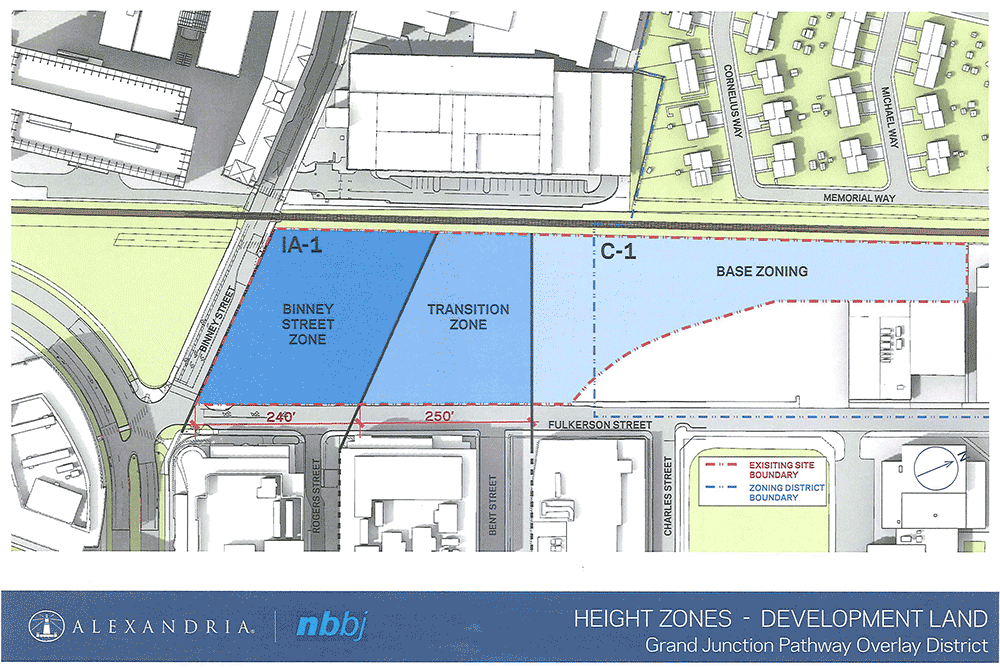
20.1009.2 Height. As shown on the attached Figure of Height Zones for Development Land within the Grand Junction Pathway Overlay District, the Development Land is divided into three zones: the Binney Street Zone, the Transition Zone and the Base Zoning Zone. The maximum height of any building in the Binney Street Zone shall be 105 feet. The maximum height of any building in the Transition Zone shall be 60 feet. The maximum height of any building in the Base Zoning Zone shall be governed by base zoning.
20.1009.3 Setbacks. There shall be no minimum required front, rear or side yard setbacks, except that no above grade building shall be constructed within twenty-five (25) feet of the westerly boundary of Tax Parcel 31-20.
20.1010 Parking--Parking Ratio.
Parking shall be at a ratio no greater than 0.8 spaces per 1,000 feet of Gross Floor Area for technical office for research development laboratory or research facility (see Section 4.34(f) of the Ordinance).
20.1011 Timing of Grand Junction Land Conveyance.
The Grand Junction Land shall be conveyed to the City per Section 20.1005 no later than the issuance of the Certificate of Occupancy for the first building constructed on the Development Land pursuant to a Special Permit granted pursuant to this Section 20.1000.
20.1012 Project Review.
In granting approval for a building or buildings under Article 19, the Planning Board may approve buildings for which physical design information is presented in conceptual form, subject to later design review and approval by the Planning Board and a finding that final design of such building(s) is consistent with Section 19.30, as applicable.
Respectfully submitted,
303/345 Binney Street
Map 31, Lot 20
By its Owner,
ARE-MAREGIONNO. 61, LLC,
a Delaware limited liability company
By: Alexandria Real Estate Equities, L.P.,
a Delaware limited partnership,
managing member
By: ARE-QRS. Corp.,
a Maryland corporation,
general partnner
By: Jackie Clem
Senior Vice-President
RE Legal Affairs
353 and 353R Binney Street
Map 33, Lots 110 and 111
By its Owner
ARE-MA Region No. 58, LLC,
a Delaware limited liability company
By: Alexandria Real Estate Equities, L.P.,
a Delaware limited partnership,
managing member
By: ARE-QRS. Corp.,
a Maryland corporation,
general partner
By: Jackie Clem
Senior Vice-President
RE Legal Affairs
686 Cambridge Street
Map 37-Lot 88
By its Owner,
RUNNING BROOK ASSOCIATES, LLC,
a Delaware limited liability company
By: Alexandria Real Estate Equities, L.P.,
a Delaware limited patinership,
managing member
By: ARE-QRS. Corp.,
a Maryland corporation,
general partner
By: Jackie Clem
Senior Vice-President
RE Legal Affairs